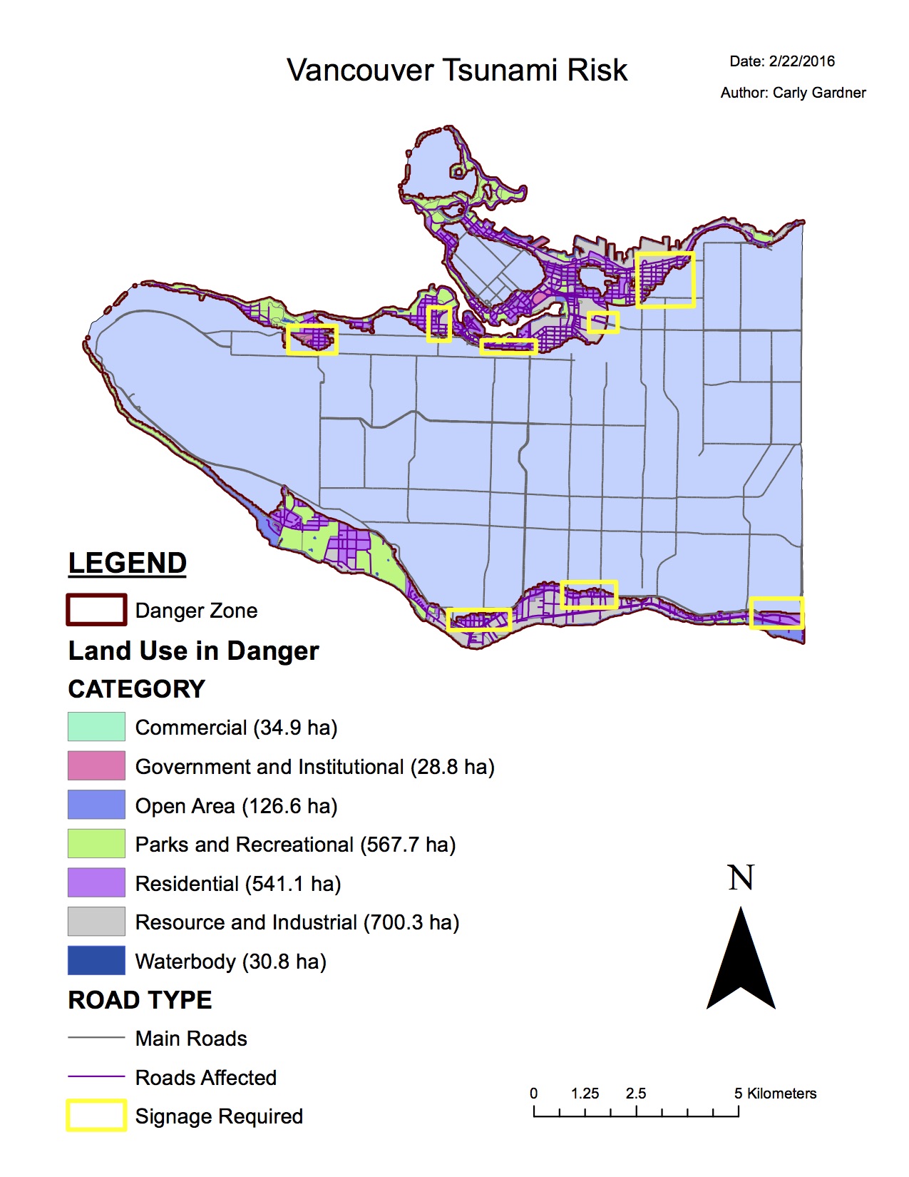
Click to enlarge map
This lab was designed to help me familiarize with spatial analysis, tables, and editing in ArcGIS. Click this image to see my map of Vancouver’s tsunami risk.
In my spatial analysis, I found that :
15.5% of the total area of the City of Vancouver is in danger of a tsunami.
For the purposes of the lab, I simplified the immediate tsunami danger zone from a 15-metre wave to be at low lying areas at or below 15 metres within 1 km from the shoreline.
To do this, I performed buffer proximity analysis by creating a 1 km buffer on either side of Vancouver’s shoreline. I also reclassified my DEM data to include only low lying areas at or below 15 metres. My lowland data was raster, so I used ArcToolbox to convert it to vector. Then I could intersect my lowland layer with my shoreline buffer (using the overlay tool) to determine which areas were susceptible to tsunamis.
By clipping this new layer solely to the city of Vancouver (Vancouver_mask), I could determine the total area of Vancouver in tsunami danger (~ 20302078 square metres). If I divided this by the total area of Vancouver (the sum of shape area in Vancouver_mask ~131010600 square metres), the resulting percentage is 15.5%.
Vancouver’s educational facilities in danger of tsunami:
- St. Anthony of Padua
- Ecole Rose Des Vents
- Heritage 3R’s School
- Vancouver Montessori School
- False Creek Elementary
- Emily Carr Institute of Art and Design (ECIAD)
- Henry Hudson Elementary
- St. Johns International
- St. Francis Xavier
- Institute of Indigenous Governance (IIG)
Vancouver’s health care facilities in danger of tsunami:
- False Creek Residence
- Broadway Pentecoastal Lodge
- Coast West Community Home
- Yaletown House Society
- Villa Cathay Care Home
These educational and healthcare facilities at risk of tsunami were determined by intersecting the areas of Vancouver susceptible to tsunami risk with layers containing educational and healthcare facilities of Vancouver. If the facilities were found within 1 km of the shoreline and were at or below 15 metres elevation, they are considered at risk.