Instead of lectures this week, we had the opportunity to listen to presentations from our classmates about the uses of GIS in landscape ecology!
One presentation I found particularly interesting was about modelling fire and landform influences on the distribution of old-growth pinyon-juniper woodland. The authors of this particular research paper created models of old growth distribution, taking into account topography and fuel in order to determine which fire risk component is most strongly associated with the distribution of old growth, and to assess the strength of the association between fire and the spatial distribution of pinyon-juniper woodland. They found that the spatial distribution of fuel material influenced the age structure of the landscape to a greater extent than topographic barriers in this particular watershed area of Nevada.
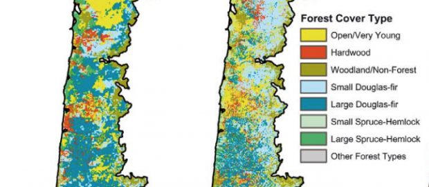
The research paper I presented was A multi-scale assessment of human and environmental constraints on forest land cover change on the Oregon (USA) coast range by M. Wimberly and J. Ohmann (2004). The objectives of this study were to to quantify changes in the distribution of major forest stand types in the Oregon coast range from 1936 to 1996; to compare the influence of human and environmental factors on land cover change; and to determine if the relative importance of these factors changes with spatial scale. The basis of their analysis used linear regression models, partial correlation analysis and stepwise linear regression in order to assess land cover change. One of their primary findings was that the percent cover of large conifer forest declined from 42% in 1936 to 18% in 1996. This forest type was largely replaced by small Douglas firs, small Spruce-Hemlock and open area. They also found that private land ownership was the most important independent variable influencing land cover change, regardless of spatial scale (sub-basin, watershed and subwatershed). Decreases in large conifer forest cover were typically greatest in hydrological units dominated by privately-owned land.
We ended up assigning this paper a 9/10 because it was well written, it acknowledged and addressed sources of uncertainty and error when appropriate, provided sources and reference material, and met all research objectives. However, their cartography and visual design could be improved.