Joanna Newsom’s “Sapokanikan”

Piotr Orlov from NPR asks “What the hell kind of word is ‘Sapokanikan‘?” He later answers, “when parsing the layers of lyrical meaning in Joanna Newsom’s new track wasn’t intriguing enough, there is first the matter of the title’s origin. ‘Sapokanikan‘ was the name of a Native American, Lenape village situated in lower Manhattan pre Dutch arrival, approximately where Greenwich Village now stands — which somewhat explains the accompanying Paul Thomas Anderson-directed video that finds Newsom wandering the streets and alleys of that New York neighborhood historically associated with cultural change.”

Director Paul Thomas Anderson is known for both his full length feature films (Magnolia (1999), There Will Be Blood (2007), and Inherent Vice (2014) – the latter of which features Newsom as a narrator and minor character) and for his music videos for artists including Radiohead, Fiona Apple, and Aimee Mann. The video gives the feeling of Anderson’s trademark long-takes (uninterrupted shots that track character movement without breaks or edits) without actually giving the shots themselves. Instead, a series of tracking shots follow Newsom around lower Manhattan and Central Park, through bodegas and bouts of unsuspecting crowds. The video can be read as a mobile exercise in mapping and layering the city, in which a history of the city is rewritten over and over again in both real-time (the filming of the video) and in subsequent viewings and performances.

There’s a nice moment at the end of the video in which a change of musical tone is matched by a modification in setting and visual tone, as Newsom – presumably by coincidence – encounters an emergency scene. In her words, “Sapokanikan is a ragtimey encomium to the forces of remembrance, forgetting, accretion, concealment, amendment, erasure, distortion, canonization, obsolescence and immortality.” That certainly clears things up.

It’s also worth noting that Newsom often switches away from conventional musical notation in her songwriting process in favour of her own system of written icons and shapes, including half- and full-moons, stars, and other cosmic symbols.

REAL-TIME LIGHTING MAP

https://www.lightningmaps.org/?lang=en#m=sat;r=0;t=3;s=0;o=0;b=;n=0;y=38.47;x=34.4775;z=3;d=2;dl=2;dc=0;

This interesting website (above) follows lightning activity across regions. Looking closer at the map one will notice how the majority of the southern hemisphere is not recorded, which leaves some outstanding questions as to why aren’t there any weather recording apparatus in those regions, and what that tells us about the conditions (socio-economic, political) of those areas.

Gerrymandering: Partisan Mapping

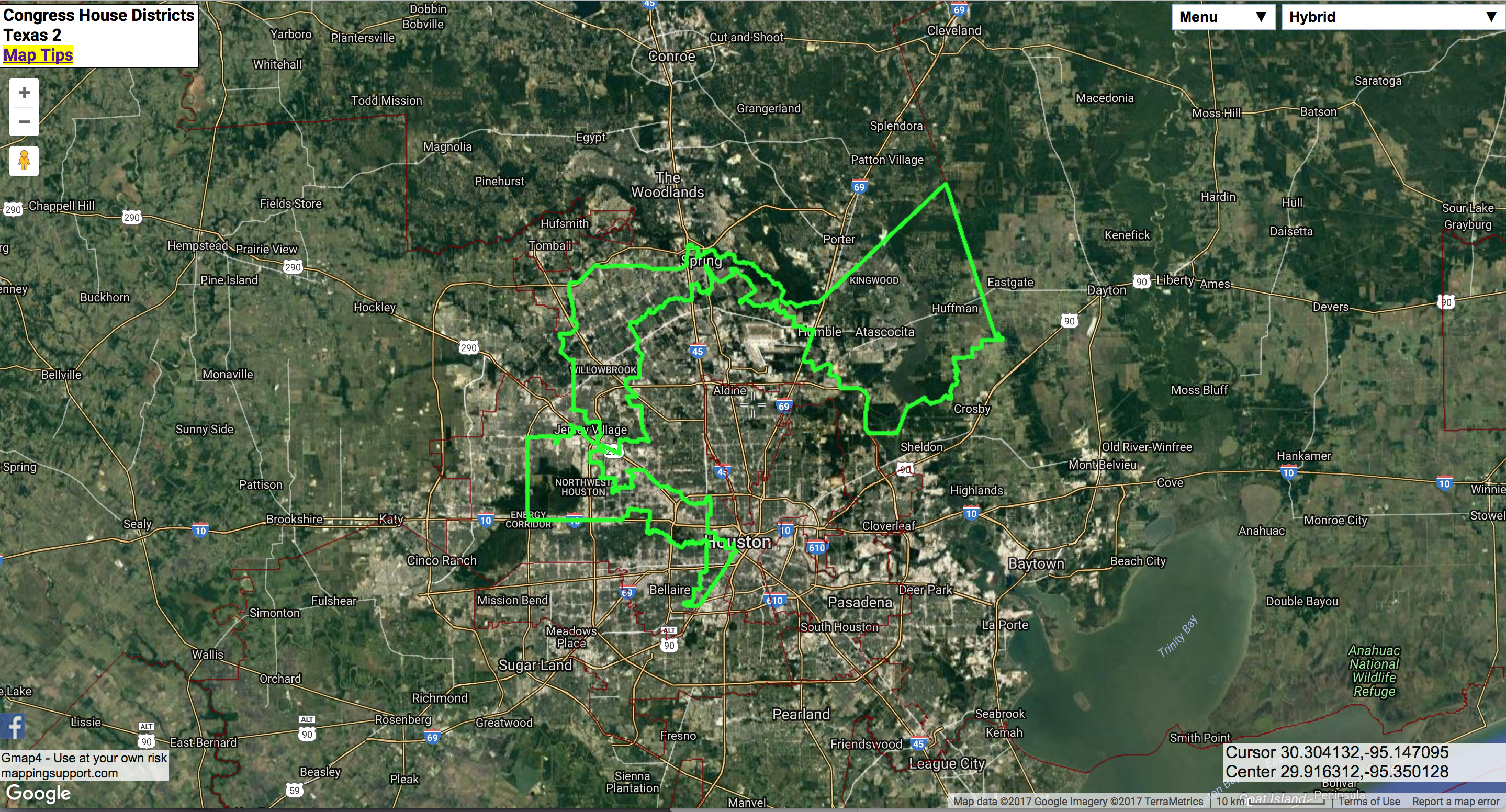
Mapping Support’s 2017 USA Congressional District Map uses GIS with Google to highlight current gerrymandered electoral districts in the US (the interactive map is worth checking out). In some states politicians (as opposed to independent  or judiciary groups) redraw voting districts to compose an electoral district that would align in the incumbents’ favor. The map above is a district that dilutes urban (more likely minority and democratic-leaning) voters with suburban and rural voters (more likely white and republican).  Not surprisingly, these maps are contentious. The US Supreme Court has ruled earlier this month that districts drawn in republican controlled North Carolina are based on race and therefore unconstitutional. The Court will also hear another important trial in which the justices may finally clearly lay out the limits of gerrymandering. The NYTimes puts it more eloquently in an editorial why politicians shouldn’t make maps.

Source: https://static01.nyt.com/images/2017/05/30/opinion/30tue1/30tue1-blog427.jpg

Save

Save

Save

MyBlockNYC

Here’s a great website that allows NYC residents  to record a video from their block and to geotag it to a map of the city. The majority of the vides were created by students in middle school and high school.

The site was exhibited at the MOMA as part of their “Talk To Me” exhibition in 2012, and was later included in the USA pavilion at the Venice Biennale in ‘Spontaneous Interventions‘.

I found the website to be a really fascinating as a way to look into the city’s often unexplored boroughs, including Staten Island and Queen’s.

MyBlock interactive Map

MyBlock overview

New York and Vancouver on Screen

Iñaki Aliste Lizarralde draws floor plans from famous TV apartments, creating real-world maps of fictional settings. His drawing of the “Friends” apartment is part of the You Are Here: NYC collection, and many of his other maps represent New York as well. For example, he has done drawings of the apartments of  Carrie Bradshaw, Holly Golightly, Will & Grace and Lucy & Ricky, all set in New York but never truly existing within the city. These sets were mostly created in Los Angeles (with exception of the apartments of Bradshaw and Golightly, which were created on stage in New York), but are nevertheless an integral part of the populace’s perception of the city of New York.

This emphasis on the New York setting leads me to think of how Vancouver does not have a single map like this, despite being a filmmaking hub. Instead maps are made of the other places in the world that Vancouver represents on screen – like the video, “Vancouver Never Plays Itself.” This video visually maps many of the places Vancouver has pretended to be and is an interesting contrast to Lizarralde’s New York floor plans.