MAP 005 CHERNOBYL

By: MAP at David Garcia Studios, 2012

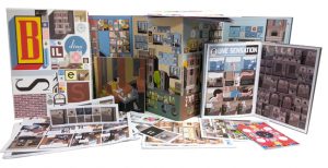
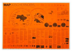
Check out the website: http://davidgarciastudiomap.blogspot.ca for more maps by MAP (Manual of Architectural Possibilities). They released a variety of series, this one in particular was done in commemorating the disaster of Chernobyl, there are others on Floods, Quarantine, Antarctica et cetera. Each series is made as a pamphlet that displays infographics on varying issues on a given theme as well as a historical briefing.

If you find this type of representation interesting I would also recommend checking out the Toronto based firm Lateral Office at http://www.lateraloffice.com, their project Making Camp also uses the pamphlet as a representational style in nostalgia for local hiker and camping pamphlets that are traditionally used. Specifically you can find it here http://www.lateraloffice.com/MAKING-CAMP-2015.

SALTSCAPES – Motoi Yamamoto

https://www.yatzer.com/return-to-the-sea-motoi-yamamoto

Regarding his work, the artist has said that: ”Drawing a labyrinth with salt is like following a trace of my memory. Memories seem to change and vanish as time goes by; however, what I seek is to capture a frozen moment that cannot be attained through pictures or writings. What I look for at the end of the act of drawing could be a feeling of touching a precious memory …”

Turning up the heat

For my personal geography project, I attempted to expand my personal heat map of Vancouver by using Strava to track 3 of my journeys: 1 bike commute to UBC and 2 walks with my dog. I then used the “flyby” feature to find records of people that cross my journey in real time. I picked one person for each journey, marked the place where we had our “missed connection” on a map and then tried to glean what I could about their lives from their internet presence, starting from their Strava profile and then jumping into other forms of social media and other websites. Finally, I wrote each person a missed connection, using popular phrases from craigslist and dropping hints about their personal lives.

This project is about how even when we are exploring a place in the physical world, like when I am getting to know my new city by walking my dog, bike commuting and going for runs, a part of us exists online, whether we are directly sharing our route via Strava or just have an online presence in the background of our minds. It also looks at how we might meet people in person versus how we meet and “know” people online.

INTERESTING CARTOGRAPHIC ANSWER TO A LAND INVESTIGATION

Mei Fang Lao, Masters Candidate at the Bartlett School of Architecture.

PROCEDURE

Students will engage the site through a series of recordings that analyze the impact of a particular phenomena on the condition of the site. Using the assigned transects, students will track the interferences that create deflections, deviations, or deformations in the volume and/or surface of the site. Students will use a notational language of mark-making to describe the force and trace of the interferences, rather than the forms. Each student will produce an analog mapping that tracks change over time along a single transect.

For further interest go to:  http://lab.visual-logic.com/academia/la-4504-hybrid-analytical-representation/001-site-mapping/

MANY MORE DIFFERENT APPROACHES ON MAPPING IN CONTEXT TO THE ABOVE PROCEDURE AT THE BARTLETT SCHOOL OF ARCHITECTURE- TAKE A LOOK AT THE LINK FOR DIFFERENT PROJECTS.

MAPS FOR A NARRATIVE ANALYSIS

http://sigliopress.com/book/everything-sings/

That a cartographer could set out on a mission that’s so emotional, so personal, so idiosyncratic, was news to me.
—IRA GLASS, host of This American Life, from his introduction to Everything Sings.

Iconoclastic geographer Denis Wood has created an atlas unlike any other. He surveys his small, century-old neighborhood Boylan Heights in Raleigh, North Carolina by first paring away the inessential (scale, orientation, street grids), then by locating the revelatory in the unmapped and unmappable: radio waves permeating the air, the paperboy’s route in space and time, the light cast by street lamps, Halloween pumpkins on porches.

His joyful subversion of the traditional notions of map making forge new ways of seeing not only this particular place, but also the very nature of place itself. In pursuit of a “poetics of cartography,” Wood makes maps in which the experience of place is primary, and the eye is attuned to the invisible, the overlooked, and the seemingly insignificant.

These maps have a traditional rigor, but they also have “fingerprints”—a gamut of subjective arguments about the relationships between social class and cultural rituals, about the neighborhood as “transformer,” about maps’ impermanence and fragility—rejecting the idea that they convey a single, static, objective truth. Together, they accumulate into a multi-layered story about one neighborhood that tells the larger, universal story of how we understand and define the places we call home.

Mapping Narrative: ‘Building Stories’ by Chris Ware

Chris Ware’s ‘Building Stories‘ (2012) consists of fourteen “easily misplaced elements;” printed works that range in format from board game to booklet to broadsheet.  These fourteen texts can be pieced together to reveal a number of simultaneous yet disparate personal narratives of residents in a three-story brownstone in Chicago. The protagonist is an art school graduate with a prosthetic leg, who experiences years that oscillate between periods of creative unfulfillment, pest infestation (the bees get their own storyline), mourning, and maternal responsibilities.

Ware leaves the reader responsible to piece together his narratives for themselves, which creates an experience that is just as alienating as it is provocative. No one document contains its own complete narrative, and thus the reading of ‘Building Stories’ is by necessity an intertextual one.  Despite the autonomy given to the reader, I couldn’t help but feel a frustration, or a “fear of missing out” on the many narratives embedded within the set.

The piece is also noteworthy in its privileging of spatial and environmental design over more accessible techniques of illustration. In his NYT review, Douglas Wolk remarks that, “The organizing principle of ‘Building Stories’ is architecture, and — even more than he usually does — Ware renders places and events alike as architectural diagrams. He’s certain of every detail of these rooms, and tends to splay their furnishings out diagonally to show how they fit together.”

Further, this work can be linked to discussions of mapping processes in our class through a passage within James Corner’s “The Agency of Mapping…,” in which he lists the “Game-board” as a “thematic development of mapping in contemporary design practice […] conceived as shared working surfaces upon which various competing constituencies are invited to meet to work out their differences” (Corner 96).

In short, the work is a great example of how different narratives can co-exist in a variety of formats and media while still maintaining a cohesive message greater than the sum of its parts.